What can I do with it?
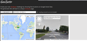
With Geoguessr you get dropped somewhere in the world in Google maps. Your job is to figure out where you are by looking around and even walking around. You have to pin point the location on a map. the closer you are, the more points you receive. With Geosettr you can create your own 5 levelled Geoguessr challenge. Normally when you go to the Geoguessr website you get a random challenge, but with the
Geosettr website you can create it and you get a link you can use to play your
own game.
Where can you find it?
http://www.geoguessr.com/
http://geosettr.com/
Who can use it?
Everybody can use it, being a completely free and web based program / game.
Pro’s:
- You can create your own challenge, for you own class. So you can adjust it to the level of the children
- You can look and walk around. in the ‘real’ world.
-You get more points the closer you get to the location
Con’s:
- You can only use it with an internet connection
-You can’t play in teams on the same device, or you have to take turns
-When you walk around you can forget where you
started.
Would I use it?
I would use it during a geography lesson. You can
create your own Geosettr with the younger groups and only set sights that are in
their own neighbourhood, or link the sights to a project you are doing in the
class. It is a great way to start a class about the surrounding en let them tell
about what they see and what elements can help them figure
out the location.
T-pack example:
Knowledge content: City or villages. What elements belong to a city and what to a village? What are the differences?
Pedagogical content:Elements of cities and villages or more easy to learn and recognise if you see images of them. This way you can make them visible and give them examples of real life.
Technological content: You have to know how to use Geosettr and Geoguessr but they are easy programs to use.
 RSS Feed